If you’re planning to visit Utah in the near future, consider paying a visit to some of its most famous ghost towns, including Grafton, Old Iron Town, Sego, and Thistle. While some ghost towns have more remains and others, each offers its own unique learning experiences that promise scenic drives and an in-depth look at Utah’s history.
Utah is home to more than 100 ghost towns, many of which got their starts as mining towns before being deserted as resources dwindled. Others found themselves at the mercy of natural disasters, like repeated flooding or landslides.
Some ghost towns are more remote than others, and the levels of safety to visit them will vary, so make sure you’ve done your ghost town research ahead of time before making the drive to one of Utah’s many ghost towns.
One last item to check before hitting the road: making sure you’re covered by the right
Grafton was founded in 1862 as a “plan B” after a previous nearby town, Wheeler, was founded in 1859 but destroyed by flooding from the Virgin River.
In its first few years, Grafton’s population grew to about 168 people from 28 different families.
Brigham Young and others were aiming to establish the area as a farming community and tested their luck with growing cotton using irrigation methods, but the environment’s growing conditions weren’t very suitable for the crop.
Other factors made daily life in Grafton difficult—and dangerous. The Virgin River’s repeated flooding damaged the town, and river silt would fill irrigation ditches. The river also isolated Grafton from easier access to nearby towns. Residents began to gradually move away.
By 1890, just a few decades after its founding, only four families resided in Grafton. By 1920, there were three families. Its Mormon church closed in 1921, and the town’s last couple moved away in 1944.
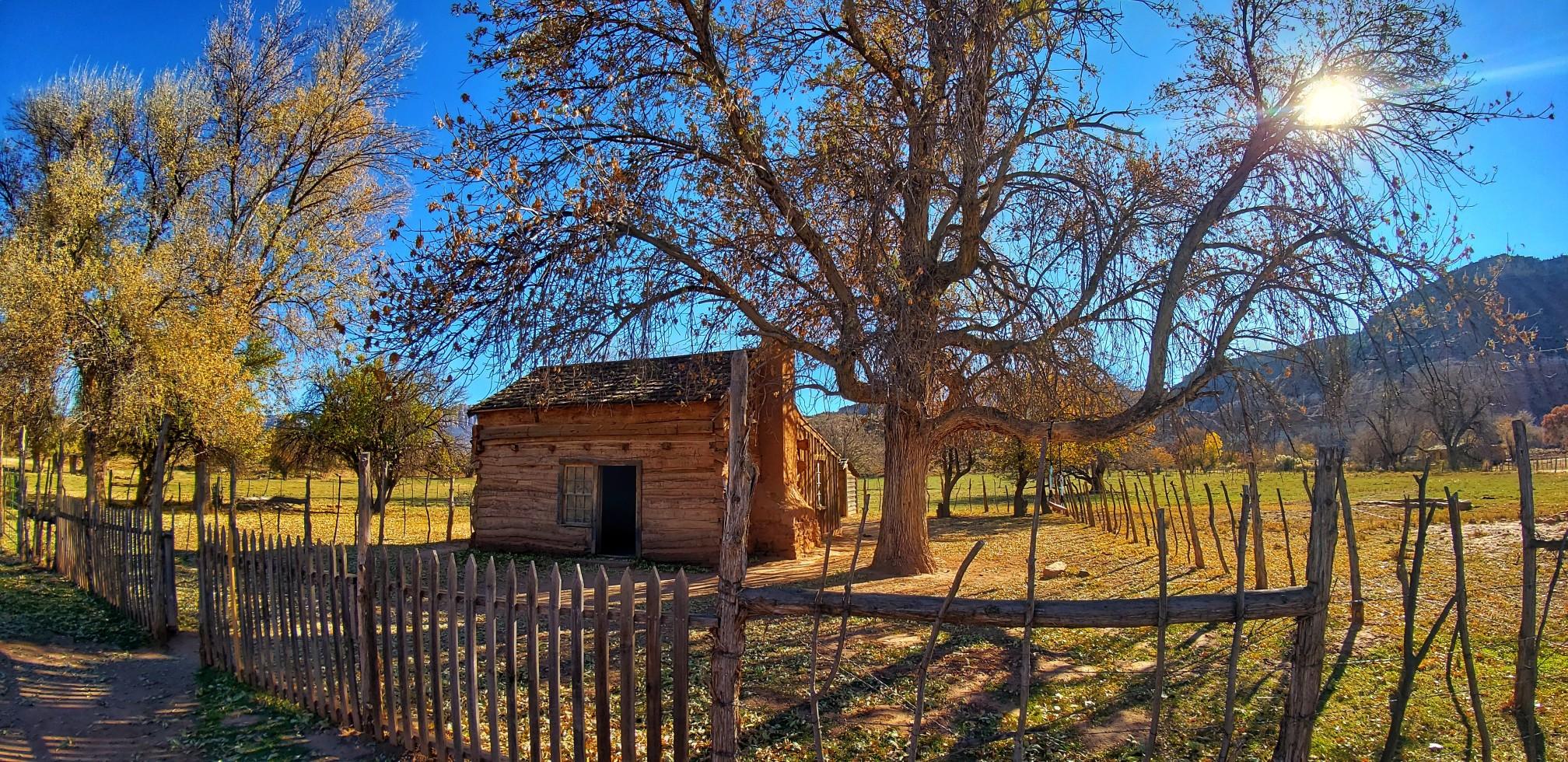
What makes Grafton special?
Today, Grafton is considered one of Utah’s most well-kept and photogenic ghost towns. Here’s what you could check out in Grafton:
A number of Grafton’s buildings remain in good condition, including a church.
Grafton lies just outside Zion National Park, so outdoor enthusiasts can consider hiking
, which passes through Grafton as well as Grafton Utah Cemetery. If you opt for a hike, taking advantage of the cooler temperatures in the early morning or evening is recommended.
Fun fact: Several films have been shot in Grafton, including the 1969 Western “Butch Cassidy and the Sundance Kid.”
Pro-tip Much of Grafton is easily explorable, but some of it is private property, so be mindful of that if you choose to visit.
How to visit Grafton
Grafton lies in the southwestern corner of Utah and is about an hour northeast of St. George, Utah.
To get there from St. George, head out on I-15 N. In about 6 miles, take exit 16 to merge onto UT-9 E toward Hurricane. As you pass through Hurricane and then into La Verkin, take a right onto UT-9 E/W State Street.
You’ll follow this road for nearly 16 miles, which winds along the Virgin River. Then, in turn right onto Bridge Road in Rockville and take another right onto 250 S/Grafton Road, which will take you into Grafton.
Old Iron Town was founded in 1868 as a mining town, with incoming residents hoping to reap iron from Iron Mountain. The town saw quick growth in its first couple of years as it reached a population of 97.
At its peak, Old Iron Town grew to 200 people. The infrastructure grew to match the population, and the town had furnaces, coal kilns, a foundry, and even a schoolhouse.
Old Iron Town’s life was short-lived, however. After the economic depression in 1873 the town dwindled and was abandoned by 1876, having hardly lasted a decade.
In 1971, Old Iron Town was added to the National Register of Historic Places.
From Cedar City, Old Iron Town is about a half-hour drive west. Take Highway 56 west about 20 miles until you see a sign for the road leading to Iron Town. Turn south onto Old Iron Town Road. You’ll follow the gravel road for about five miles, and you’ll see what remains of Old Iron Town on your left as you arrive.
At its height, the now-deserted Sego was a coal-mining town, and the town was reinvented many times throughout its heyday.
One of the founders of nearby Thomspon Springs, Henry Ballard, found coal in the area in 1908 and established a camp there, which he named Ballard after himself. Not long after, a mine was established in the area and the town was renamed Nelsen after the mine’s general manager.
In 1918, Nelsen was renamed Sego after Utah’s state flower, the sego lily, which could be found growing around the area.
From the beginning, Sego had its difficulties. Its water supply couldn’t keep up with its population growth. Meanwhile, the railroad experienced repeated damage from flash floods. Frequent power outages in the mines also became a problem, and the mine began had also begun experiencing financial problems.
Many miners ended up leaving, but a small number stuck around. The dwindling town held on a while longer, but then it was ravaged not once, but twice by fire between 1949 and 1950.
The U.S. Census records Sego’s peak population as more than 200 in 1930.
Over the following decades, flash floods continued to ravage the area. A 1950s flood destroyed many remaining homes. Another flood in the 1980s forced out the majority of people still living there.
What makes Sego special?
Here are some things to know about Sego:
Visitors could once observe the remaining wooden boarding house, but it collapsed by 2010.
Today, the company store made of stone still partially stands, along with some previous homes’ foundations.
Some underground coal fires in the mines are still burning to this day.
Sego lies in eastern Utah, not too far off I-70. It takes about 3.5 hours to drive to Sego from Salt Lake City.
From Salt Lake City, head south on I-15 S for about 50 miles, then take the US-6 E exit toward Price. Stay on US-6 E for about 128 miles. Then, merge onto I-70 E and continue 28 miles. Take exit 187 toward Thompson Springs.
From Thompson Springs, head north on BLM159/Thompson Canyon Road. Continue for about 3.4 miles, then turn right onto Sego Canyon Road, where your destination lies up the road about a mile.
Thistle was an agricultural community founded in 1883, and home to many cattle ranchers in the area. In 1878, a railroad was built in the town, which increased traffic to and from Thistle.
Thistle reached its peak population of 600 in 1917. At that time, it had a depot, a school, a post office, a barbershop, a saloon, and several restaurants.
In the 1950s, diesel trains had largely replaced steam-powered trains, which lowered the number of stops a train would need to otherwise take for water refills. Fewer stops in Thistle caused the population to begin waning.
The year of its centennial, April 1983, an enormous landslide after a year of record precipitation forced Thistle’s remaining few residents to quickly evacuate. The landslide formed a dam more than 200 feet high that blocked the Spanish Fork River. In addition to the damage done to Thistle, it flooded two highways and cut off railroad access between Salt Lake City and Denver.
” in U.S. history with more than $200 million in damages.
What makes Thistle special?
While you might not be able to walk through Thistle, you can still observe what once was from afar. Here are some things to know:
Thistle stands out in the sense that it’s a more recently deserted ghost town, having only met its official end a few decades ago.
Little remains of Thistle, but driving along Route 89, you may be able to see houses or rail cars emerging from the water, while others are buried by silt.
More minor landslides have continued in the area since the 1983 landslide.
MORE: Utah Electric Vehicle Incentives
How to visit Thistle
Thistle is about an hour’s drive south of Salt Lake City. There are a couple of
with informational signs that can give you a good sense of Thistle.
From Salt Lake City, head south on I-15 S toward Spanish Fork. Take the US-6 E exit and continue to US-89 S. For the downstream view, after about 11 miles, take a right onto Spanish Fork River Park Road. Or, you can continue about 12 miles from I-15 and turn into a “large pullout.” About 1.5 miles on from the pullout is what remains of Thistle and more informational signs.
Thousands of customers saved on average $887/year on their car insurance with Jerry
This app is great, but the customer service is even better! Not to mention convenient! My husband and I got the lowest rate (much lower than the rates I was finding online through my own searches), quickly, and pretty much all through text message! Thank you so much for a hassle free experience👍
Ghost towns can be full of thrilling haunts and surprises, but don’t let the drive there be. Make sure you’re covered for the unexpected on your ghost town visits with the right car insurance.
can make the process quick and easy for you! After answering a few questions, you can review quotes from top insurance companies, including Travelers, State Farm, and Nationwide, to find the right policy at a good price.
You could enjoy some significant savings, too. Average Jerry users save $887 per year on car insurance!
blew my mind, honestly. From start to finish, using the app took me 10 minutes and I ended up with $100 of savings a month. Best of all, customer service answered all my questions about rental car reimbursement and roadside assistance.” —Savanna R.


.webp&w=3840&q=1)


 4.7
4.7.webp&w=64&q=75)